

EXPLORE THE PROPOSED WALKING AND BIKING FACILITIES MAP
How to Use This Map: Click the tab in the top left hand corner of the map to view the layers. You can click the check marks to hide or show layers. If you click the lines on the map, you can get more information.
More about the draft Walking and Biking Network recommendations
The draft walking and biking network recommendations include:
- Filling sidewalk gaps where sidewalks do not currently exist.
- Adding bicycle facilities to connect major and everyday destinations, improve safety, and connect to the regional trail network.
- Making intersections safer that have a higher risk of a pedestrain or bicycle crash or when adding a sidewalk or bicycle facility to the street.
The draft biking network includes major north-south and east-west “spines”, and “network connector” routes that connect the spines.
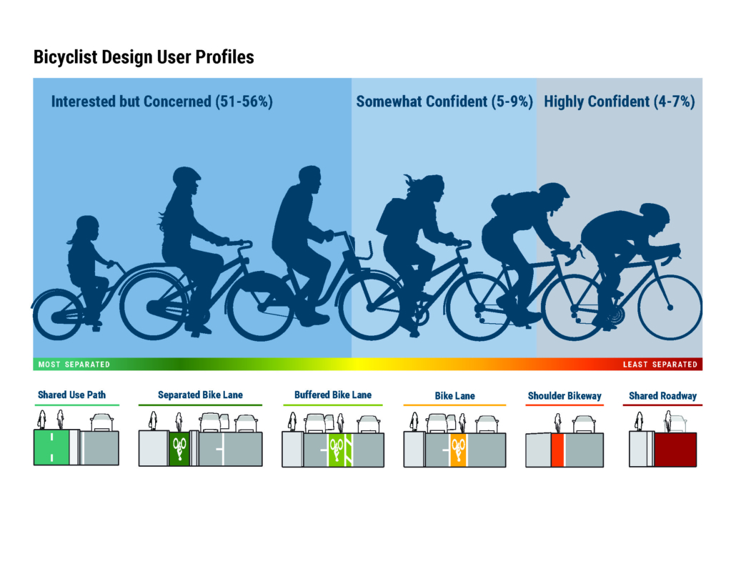
We want Dayton’s bicycle network to meet the needs of the majority of riders. Bicycle facilities are currently defined as On Street or Path (Off Street), and the exact facility types will be determined during design. Lower-stress streets (low volume, low speed) are usually best for bicycle boulevards or striped bike lanes, while higher-stress streets (high volume, high speed) need more separated facilities like cycle tracks and paths.
Below is a graphic of the type of bicyclist associated with the type of roadway and facility they might be comfortable riding on.

REVIEW THE DRAFT POLICY AND PROGRAM RECOMMENDATIONS
Education and Outreach
Trainings & Curricula
Train teachers on safe walking and biking practices and road rules so that they can educate students on safe walking and biking practices. Training for students and youth could be part of classroom curriculum, physical education courses or through the Safe Routes to School (SRTS) program.
Bike and Pedestrian Safety Training, Policies, and Conversations with Police Department
A series of trainings and community conversations with the City of Dayton Police Department to learn about bike and pedestrian safety, policies, and laws and how to positively interact with the bike and pedestrian community. A related Police Reform Working Group initiative that can be incorporated into these trainings, is Training Recommendation 21 focused on making data collection from bias-free policing policy publicly available including data on race and gender on all traffic stops (driver only) and traffic crashes (driver only)
Community Ambassadors
Establishing a community ambassador program where community members can lead initiatives that promote active transportation and educate Dayton community members about traffic safety. The ambassador can help develop recommendations to develop safe, viable, and accessible transportation options as well as be a spokesperson for key updates regarding active transportation projects in Dayton. This could be training a volunteer from each Neighborhood Association. One example of an initiative that community ambassadors can lead, is bike registration. Bike registration programs are typically managed at the local level through municipal police departments, though there are non-profit bicycle registration programs across-jurisdictional boundaries. Registration programs record information about the bike and the bike owner, stored in an online database that increases the rate in which stolen bicycles are returned to their owners without requiring much effort and funding by the police department.
Bicycle Friendly Businesses
Bicycle friendly businesses encourage people to ride a bike by providing incentives to customers who arrive by bicycle. Incentives include providing bike parking (sometimes on-street bike corrals or custom designed bike racks), a repair station, or hosting bicycle events at their business. Businesses participating in bicycle friendly businesses often display a sign provided by the program that states they are a bicycle friendly business. These programs are often managed by local bicycle advocacy organizations, like Bike Miami Valley’s, municipal planning or transportation departments, or local chambers of commerce.
Dayton Bike Route Map and Educational Resources
Create an updated bike route map for the City of Dayton. The goal for the City’s bike map is to host an interactive version on the web versus printing annual updates with destinations, city and metro parks, Miami Valley Trail connections (regional map), accommodations, libraries, and schools identified. Bicycles for All can also provide community resources that promote biking for recreation, transport, and sport. This could also include educating people on how to report maintenance issues for active transportation facilities through the Dayton Delivers App.
Walking and Biking Events
Host organized events focused on using active transportation. This could include events, such as themed walking tours to encourage walking in different parts of the city, how we roll rides, and bike month events. Events could highlight city history, focus on health (like past “Walk with a Doc” programs), and/or be aimed at a specific age or socio-demographic.
League of American Bicyclists: Bicycle Friendly Community Program
The League of American Bicyclists’ (LAB) is a national cycling advocacy organization and helps provide guidelines for communities to improve cycling conditions. The City of Dayton is currently at Bronze status. The city can review what steps are needed to achieve Silver status and work toward Silver status as the Plan is implemented.
Health and Safety
Adopt a Vision Zero policy and Vision Zero Action Plan for Dayton
A Vision Zero Policy commits Dayton to working towards zero traffic‐related deaths and serious injuries. A Vision Zero Action Plan would clearly outline departmental responsibilities and a decision making framework for the City of Dayton to prioritize actions that will help the City eliminate traffic-related deaths and serious injuries. Vision Zero can be incorporated in the City’s Safe Street and Roads for All Action Plan.
Non-law enforcement/ Un-armed enforcement traffic response task force
This system would allow for a new model where un-armed enforcement intervenes with low-level traffic offenses, such as failing to wear a seat belt or driving with an expired license plate. Community leaders, City of Dayton employees, and law enforcement can work together on creating a system or task force that responds to low-level offenses. The intent of this approach is to move toward making streets safer without increasing the amount of traffic stops conducted by armed enforcement. The City of Berkeley, CA is currently exploring a similar program (Berkeley, CA). A related Police Reform Working Group initiative that could inform a program like this is Training Recommendation 34 focused on having an external agency conduct a traffic stop analysis to identify if disparate enforcement is being used
Make it easier for people to choose active transportation modes
Support public education and outreach initiatives aimed at giving Dayton residents the information, skills, and practical experience to take advantage of alternatives to driving a car. Examples include individualized assistance with transit or multi–modal trip planning, learning how to use bus-mounted bike racks and getting paired with a bike buddy for first-time bicycle commuters. This could include promoting MVRPC’s Drive Less, Live More program and Miami Valley Rideshare Program. This program allows residents to map their route, find others to join their bike commute, and track their CO2 emissions and money saved for each bike trip made.
Automated Speed Camera Enforcement
Speeding is a primary factor in crashes. Speed safety systems have been shown to reduce violations and crashes dramatically at locations where they are deployed. Speed cameras will photograph a motor vehicle’s license plate if the driver is speeding and then the vehicle owner or driver is sent a ticket. People of color are disproportionately harmed by traffic violence. Carefully deploying automated traffic enforcement systems to reduce speeding, crash-related injuries, and property damage can also help reduce racial biases. Currently, temporary speed enforcement cameras are used in several school zones in Dayton. Depending on state legislation, the city can consider expanding the use of cameras to other areas of the city. In addition, the city could explore graduated ticketing based on income, so that ticketing does not disproportionately impact people with lower incomes.
Alignment and Collaboration
Pursue grant funding sources for pedestrian and bicycle facilities
Coordinate funding for pedestrian and bicycle facilities across departments as appropriate. Pursue federal, state, and regional grants and funding
Develop an internal protocol system to address active transportation issues and complaints
Establish a multi-jurisdictional protocol where issues, requests, and complaints are properly filtered and sent to the correct department in Dayton to address the request, issue, or concern.
Review and update city maintenance practices for walking and biking facilities and coordinate with regional agencies
Review and update city maintenance practices for walking and biking facilities, such as routine maintenance and snow removal.
Bike.Walk.Ride Annual Action Plan and Community Conversations
Establish a charter for the Bike.Walk.Ride committee that laments the committee’s goals and action items. Propose that they lead the conversation and document progress for each goal (education and outreach, health and safety, etc.). The committee members should reflect the diversity and lived experiences of Dayton residents.
Actively participate in the Miami Valley’s Regional Active Transportation Committee
Continue to actively support and collaborate with neighboring jurisdictions on the implementation of the regional Active Transportation Plan.
Update policies and guidelines
Update existing policies and guidelines to reflect the current best practices for traffic safety, active transportation, such as Bike Parking Guidelines, design standards, land use, development review, and 85th percentile speed-setting, etc.
Equity and Access
Expand access to free and low-cost bikes and gear
Many populations, including older adults, children and teens, people with disabilities, low-income people, people of color, and people experiencing homelessness often lack access to bikes. Work with bike shops and charities to provide refurbished, free, or affordable bicycles, e-bikes, cargo bikes, and trikes or other adaptive devices. Explore developing a bike library where bikes can be checked out or a bike and gear giveaway program for low-income community members, including children, to foster a culture of safe riding practices; include high-quality locks, lights, baskets or panniers, and helmets.
Public Participation and Compensation
To better understand and address the active transportation needs of historically marginalized communities, formalize community engagement practices that partner with Black, Indigenous, and people of color (BIPOC) community organizations and compensate community members for their time. Topics to discuss could include traffic safety, data or topics historically marginalized communities would want to discuss with the police department. Consider engaging with civil liberty, racial equity, and economic justice organizations. The city could explore funding options for a Health Equity Coordinator(s) position to oversee these efforts and/or ongoing engagement efforts could be tasked to the Bike.Walk.Ride Committee.
Infrastructure and Services
Scooter Share
Similar to a rideshare, provide residents with scooter share options within the Miami Valley Region and Dayton, Ohio. In collaboration, the city should look to expand the service area to underserved communities and offer discounted membership for low-income residents.
Dayton Bike Share (Link)
Founded in 2015, Link is the Dayton bike sharing system. It is a hub-based system that allows users to access bikes at 37 different locations in Dayton. Users can use the bike share system through an app. Since launching, 18,500 users have taken over 140,000 trips. Dayton Bike Share is operated by Bike Miami Valley and Greater Dayton RTA. Expand the bike sharing program by establishing more hubs in underserved communities. Link, the City of Dayton, Bike Miami Valley, and Greater Dayton RTA, should explore offering discounted membership for low-income residents.
Spread transit awareness
In collaboration with the Greater Dayton RTA, continue to promote transit to help community members learn about different public transit options (SMART, FAST, Paratransit).
Increase transit access
Ensure safe and comfortable walking and biking connections to all RTA stops and transit centers within the city. Efforts can include identifying, prioritizing, and filling gaps in sidewalks, and ensuring midblock bus stops have a safe crossing.
Install Bike Racks
Businesses, schools, and key destinations can help encourage biking by providing bicycle parking. Work with local businesses to sponsor bike racks, especially indoor or sheltered bike parking. Also, the city could require bike racks be built when there is new development.
Demonstration Projects
Familiarize community members with biking or pedestrian infrastructure through a demonstration project. This will provide a greater understanding of how the public will react to change. Additionally, demonstration projects allow for the public to give feedback and provide support if they are in favor of the project.
Open Streets
Work in collaboration with the organizations that plan the closing of E 5th Street in Oregon District and Monument Ave to develop a recurring program that opens streets to people walking and biking by temporarily closing access to motorists. The city could explore expanding the program to other streets in the city. Open Streets events give communities another perspective of how streets can be used for active modes and encourage people to walk and bike.
Wayfinding Program
Identify key neighborhood destinations and paths and establish wayfinding signage to guide people walking and biking. Signs can focus on community nodes such as Downtown Dayton, commercial areas, parks, schools, etc. The wayfinding program would be linked to the Dayton Bike Route Map. Downtown wayfinding signs have been designed for downtown and the City can support Downtown Dayton Partnership in the implementation of those signs.
For more details click on the link below

TELL US WHAT YOU THINK
After reviewing the draft recommendations, please complete the following form:

JOIN US IN-PERSON
We will be at the Second Street Market (600 E. Second Street) on April 29th from 9am to 3pm. Visit the Community Table on the western end of the market to provide input.

Thank You For Your Input!
Click on the links below for more details on the planning process


")